Little more than a year since the access
steps from Cemetery Road to Iromills Park were restricted for access due to
land slip, it is reported that a six figure sum will be required to make good
the land erosion. There’s no clear guidance whether that includes the cost of
replacing the access steps and associated works.
That leaves the Memorial Footbridge
built in 1913 at the bottom of the steps as a “bridge to nowhere”.
Not so very long ago I had hoped that
the bridge would be cleaned up and re painted in time for its centenary in
2013. Instead it’s looking as if 2013 could mark its potential demise by lack
of use.
I’m seeking assurance that the bridge will be protected and cared for. Why? Read on.
I’m seeking assurance that the bridge will be protected and cared for. Why? Read on.
Why was the bridge built and what is its history?
The bridge simply connects Ironmills Park
to Cemetery Road at one of the steepest part of the gorge cut by the North
River Esk. It was built 4 years after the Duke of Buccleuch gifted Ironmills
Park to the town on the occasion of His Grace’s Golden Wedding.

Photo from Del Hanlon. Date of photograph 1913

Dedication of the park. Photo 2014.
The bridge was designed by Charles Greig and it was listed as grade B in March 1992 by Historic Scotland, ID 24429. Its post-code is EH22 3BL.
In 1967 there is a report of a
subsidence survey to assess possible mining related damage to the bridge. Dated
12/07/1967, the existence of this survey is recorded in the Scottish Mining
Museum web site. I have never seen the report.

Photo from the Mining Museum web site.
Date of Photograph 1967
To see the bridge throughout time, Canmore Images is a great source of photographs. Here are 2 examples.
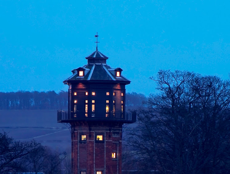
The bridge and the water tower
 |
View from the West
 |
Possible Date of Photos.
- re your
request about the photo, I did a bit digging……I reckon that the photos were,
almost certainly, taken at the same time,and, probably, by the guy who wrote
the 'paper' …….. winter-time, early 70's. They just don't look like early 20th
century photos to me, with the combination of image 'quality' and the shape.
They also have a 'snapshot' air about them (tower's leaning in the one you
posted), which the early photographers couldn't afford to do with their glass
plates. Image copyright also belongs to 'John Hume'.
And if I have to be pedantic, I'd
say January/February 1973/74
for your photos, given the condition of the trees and how low the sun appears
to be.
John.
Any Other Uses?
It is not clear if the bridge was used
as a conduit for a water pipe to the Dalkeith Water Tower (built 1879). Water
from a bore hole in the park was certainly pumped to the tower in 1910 and it
seems reasonable to believe that the conduit used before the bridge was built,
continued to be used.
What About The Bridge Nowadays?
Well the bridge is structurally sound
but it is looking very tired. Ivy has taken hold and the paintwork is flaky.
The council has responsibility for its maintenance but given the economic
conditions it is unlikely that this would permit anything more than bare
necessities.
In 2009 I hastily organized a centeneray
celebration for 100 years of the gift of the park and set about trying to
establish a Friends of Ironmills Park
group to assist with refurbishment of the bridge in time for its centenary. It was a good event and the
council paid to have 6 trees planted to commemorate the event.

The “ Friends of…” group never
established but local councilors committed to use their environmental funds for
the cost of cleaning and painting the bridge. Sadly though local elections
interfered with progress and then in 2013, land slip started to appear around
the steep bank above the bridge.
Any opportunity to celebrate 100 years
of the bridge slipped along with the land.
So What Does The Bridge Look
Like Now?
Some photos from the last 10 years or
so…


Post Land Slip – What Now?
Well the local council will assure the
future safety of the bridge. At the moment Heras fencing and barbed wire
signify “Do Not Enter” although that doesn’t stop everyone. The young, fit and
able continue to break through the barriers and use the bridge and the
overgrown, land slip affected steps above. The ground has heaved around the
path and the corner steps; the hand rail has twisted and almost snapped under
the pressure from below. Rust is setting in, ivy is taking hold and the plants
will claim the land in due course.
The council has surveyed the land slip;
it is still moving. Ironside Farrar have been contracted to assess the reasons
for the slip and suggest means of repair. It is not good news. The repair is
said to be a 6 figure sum. Not the few thousand anticipated. The reasons why it
has slipped have not been made public but speaking to the contractors, it is
almost always due to water, probably from more rainfall than usual. Then the
weight of the soil above the rock finally gave way. The contractors found
Boulder Clay beneath the soil. This stuff is as good as rock. Water does not
penetrate but slips along the surface, maybe finding a crack or area to
penetrate. Maybe to saturate a point area to liquefy the sand layer, allowing that layer the free movement that has taken that material into the river Esk last year. The weighty soil above
the sand layer clings on thanks to tree roots and shrubs and I guess its weight.
Hopefully it clings on for a long time. To safely repair the steps though would
require that soil to be removed from the rock and with that the trees and all
the roots. The extent of the removal might have to be well beyond the line of
the land-slip crack. There’s a lot to be concerned about. A similar event
occured on the opposite side of the river at Lugton Brae a couple of years
ago. Some 1.9 Million £ later (and that figure could be ecomomic with the whole
cost figure) the road at Lugton has been repaired and it has just been re opened to public this week.
But this article is dedicated to the
bridge and its long term security and use. The bridge doesn’t seem to be at
risk and maybe the public could be allowed to continue to use the bridge as a
viewing point. The barrier to the steps above could be made in aesthetically
pleasing materials just beyond the bridge and maybe funds could be found to at
least remove the ivy and clean up the surfaces. A lick of paint surely wouldn’t
go amiss. But I tell you, the last time I muted some paint on the bridge the Health and Safety police took over to make sure no flaky lead filled paint
got into the river. A simple strip and paint turned into a suggestion that the railings
be removed, sent for shot blasting and then painted and re instated. Consequently nothing happened at all. I'm sure we could have used an old blanket to catch the flaky paint and easily have primed and painted the rails. It wasn't to be.
As for the land slip, time will either heal the slip with the benefit
of light and plant growth (possibly with the gradual reduction of
the light stealing, thirsty Sycamore trees on the slope) or funds will be found
to scar the area by complete removal of all affected
soil and plant life and then make good. It’s all up for discussion and opinion
as to what’s the best course of action. I personally would prefer the former rather than drastic major works which might just shake the earth so much that another area of land will slip.
Meantime the bridge and the steps leading to it are starting to look
very sad.


and the steps are not good.....


