| | Planning CommitteeTuesday 12 April 2011 Item No 7(b) |
APPLICATION FOR PLANNING PERMISSION (10/00694/DPP) FOR THE ERECTION OF TIMBER DECKING WITH STORAGE BENEATH, ERECTION OF BOUNDARY FENCE INCORPORATING A BIN STORE, WORKS TO STABILISE BANKING, ALTERATIONS TO PATH, FORMATION OF WOODLAND ACCESS STEPS, AND ERECTION OF ASSOCIATED GUARD RAILS (RETROSPECTIVE) AT RP9, THE WATER TOWER, CEMETERY ROAD, DALKEITH
Report by Head of Planning and Development
1 LOCATION AND SITE DESCRIPTION
1.1 The site extends to approximately 465 square metres and comprises the garden ground of the dwellinghouse referred to by the applicant as “RP9”, and an area of private woodland. Historically the easternmost part of the site was the garden for Cemetery Cottage and the Water Tower, and the area of woodland to the immediate north and west of the application site, is also owned by the applicant. The total area of land owned by the applicant is approximately 0.5 hectares.
1.2 The site is located above the south eastern bank of the River North Esk approximately 25 metres from the edge of the river channel and 22 metres above the water level. The site is on the opposite side of Cemetery Road from the Water Tower and Cemetery Cottage. To the south of the site are two tennis courts, a tennis club building, and the associated fencing. To the north, beyond the River, is Ironmills Park within which lie the former mill buildings now in residential use, and a footpath leading down to it, via a footbridge, from Cemetery Road.
1.3 For the avoidance of any doubt in the consideration of this application, the curtilage of the dwellinghouse is taken to be that area bounded to the south by the tennis court fence, to the east by the wall and the timber fence (forming part of this application) to Cemetery Road, to the north by the planted wildlife hedge extrapolated to the west boundary, and to the west by the boundary as shown on the site plan attached to this report.
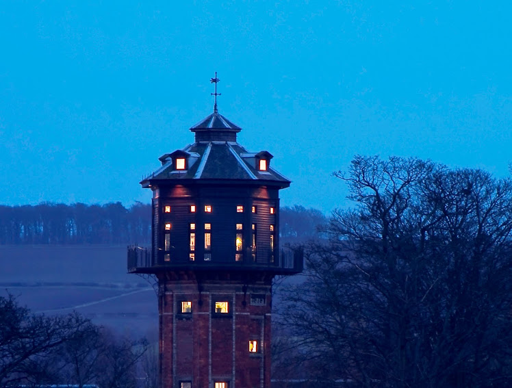
1.4 The site is located within the Eskbank and Ironmills Conservation Area.
2 PROPOSAL
2.1 The applicant is seeking planning permission for the following retrospective works:
· a raised timber decked terrace with a glass and timber balustrade. The decked terrace has a timber clad storage compartment beneath and measures 2.4 metres in height to the top of the balustrade. The decked area measures 3.4 metres by 4 metres;
· a replacement boundary fence leading from the boundary wall on the eastern edge of the site towards Ironmills Park, and incorporating an integral bin store and double gate. The fence is approximately 1.9 metres high;
· a timber structure to widen and secure the footpath to the woodland at the west end of the garden; and
· the creation of a woodland access path and steps with associated handrail leading down the slope to the north of the dwellinghouse.
2.2 There is also one element of the proposal that is not retrospective which is the extension of the woodland access path to the west boundary of the site. This is proposed to match the existing path.
2.3 This application relates to works all within the boundary of the application site.
3 BACKGROUND
3.1 Planning permission (08/00541/FUL) to “Amended design for the new dwellinghouse approved under planning permission 06/00702/FUL” was approved on 21 October 2008. The main changes were that the eaves level was dropped significantly to create the appearance of a single storey building with developed roof space with rooflights. The resultant building had a larger footprint, though much of this comprised a covered veranda on two sides of the building. The internal floor area was not significantly increased, and the design was considered to be of a higher standard.
3.2 There have been two subsequent non-material variations to the above application since approval. One was to move the whole footprint around 2 metres closer to Cemetery Road, and the second was to amend the design and enlarge the rear (west facing) veranda.
3.3 Planning permission had originally been granted in February 2007 for a dwellinghouse on this site (06/00702/FUL), subject to conditions.
3.4 Planning permission was refused in 2005 for an application for the erection of dwellinghouse and guest accommodation (04/00209/FUL). An appeal was submitted against this decision and was subsequently dismissed on 06 December 2005. The reporter considered that there would be likely to be an adverse affect on the character of the woodland through possible tree felling and lopping/pruning; the architecture of the buildings was out of keeping with the character of the conservation area as well as being visible from the park; and was contrary to 2003 local plan policies RP5(Woodland, Trees and Hedges), RP7(Landscape Character), RP19 (Development within the Built-up Area) and RP20 (Conservation Areas).
3.5 Planning permission for the erection of a garden hut (gazebo) was approved on 08 April 1998 (0122/98). This is sited on land which formed the garden area for Cemetery Cottage prior to the purchase of land from the Council.
3.6 Outline planning permission for the erection of a dwelling house on land opposite the Water Tower, part of the site closest to Cemetery Road, was refused on 10 May 1996 (0593/95). The reasons were that it had not been adequately demonstrated that the development would not harm the character of the conservation area; the development would require removal of a large section of boundary wall; it would endanger the health of a large sycamore tree; the garden ground was too small to accommodate a dwellinghouse; it would exacerbate on-street parking problems; and the access from Cemetery Road to Eskbank Road was substandard.
3.7 The land to the west side of Cemetery Road, incorporating the existing dwellinghouse and the surrounding woodland was all previously owned by Midlothian Council prior to the sale of Cemetery Cottage and the garden. As a consequence of burdens placed upon the land, the Council is currently pursuing certain matters with the purchasers of the land. Whilst this is not a material planning consideration in the determination of this or any previous planning application, it does mean that the Council has a financial interest in the application and the application is reported here to the Planning Committee, in accordance with the relevant provisions of the Planning (Scotland) etc Act 2006.
3.8 There has been a recent history of work to trees including tree removal on the site. Some of this has been agreed formally either through an application for tree felling or as part of the woodland management plan, however there is other work that has not been consented. The tree removal has taken place on the steep slope leading down towards the River North Esk. Consent is required due to the site being within a designated conservation area.
4 CONSULTATIONS
4.1 No external consultations were undertaken for this application.
5 REPRESENTATIONS
5.1 There have been 33 representations received in total. These have been received from local residents, the Esk Valley Trust, Eskbank Amenity Society, and other interested parties. There are 15 objecting to the proposals, and 18 in support. The issues raised objecting to the proposal are as follows;
· The poor quality of the submission and lack of scalable drawings;
· Lack of any context as to the various photograph’s locations, and the numbers on the site plan do not refer to specific photographs;
· The development has extended beyond the area permitted for development by the legal burden placed on the sale of the land;
· Some of the proposed works breach a “No Building Burden” that was a condition of the sale of the land;
· Not all works are within the defined garden area of the house;
· The fence is too high and it obscures the view of the woodland;
· The fence is a barrier to wildlife;
· The hedge would block the footpath if permitted to become overgrown;
· The raised platform is visible from the park;
· There is no specific locational need for the raised deck, bin store, or slabbed paths (under policy RP9);
· The incremental development is contrary to policies RP5 and RP7 as they have resulted in the erosion of the woodland and are visible and are detrimental to the landscape character of the area;
· The approval of the current application would undermine the Council’s policies designed to protect this area;
· The woodland area has become overdeveloped and its character lost;
· Adverse effect on the setting of Ironmills Park;
· New planting will take too long to establish;
The issues raised by supporters are as follows;
· The development is a good model of environmentally friendly design, built with consideration to its surroundings;
· The house demonstrates that living accommodation can be a positive benefit to its environment;
· The work to the woodland needs more time to develop when the clearance of deadwood and undergrowth and the establishment of new planting will soon be appreciated;
· The steps, sitting area and paths complement the existing house and fit well into the surroundings;
· The works are an ongoing part of the applicant’s long term achievements in improving the area, which commenced with the refurbishment of the Water Tower;
· The path improvements are required due to bank erosion caused by rainwater runoff from the tennis courts;
· The development is very low key and eco friendly; and
· The works have improved the safety at the top of the embankment;
6 PLANNING POLICY
6.1 The development plan is comprised of the Edinburgh and Lothian’s Structure Plan 2015, approved in June 2004, and the Midlothian Local Plan, adopted in December 2008. The following development plan policies are relevant to the determination of the application:
· Policy RP5 Woodland Trees and Hedges does not permit development that would lead to the direct or indirect loss of woodland which has a particular value in terms of amenity, nature conservation, recreation, landscape character or shelter;
· Policy RP7 Landscape Character which advises that development will not be permitted where it may adversely affect the quality of the local landscape. Provision should be made to maintain local diversity and distinctiveness of landscape character and enhance landscape characteristics where improvement is required;
· Policy RP8 Water Environment aims to prevent damage to the water environment, including groundwater and requires compliance with Scottish Environment Protection Agency's guidance on Sustainable Urban Drainage Systems;
· Policy RP9 Protection of River Valleys requires development within the river valley protection areas of the Rivers North Esk, South Esk and Tyne to have a specific locational need for the development, and where this is established, development must demonstrate that it will not have an adverse impact either on the landscape and conservation value of the valleys or impede potential public access opportunities;
· Policy RP14 Habitat Protection Outwith Formally Designated Areas advises that, effects on the habitat, including the expected results of mitigation measures, will be taken into account, and where appropriate, planning conditions will be used and legal agreements sought to ensure protection of habitat during development and in the long term;
· Policy RP20 Development within the Built-up Area which advises that development will not be permitted where it is likely to detract materially from the existing character or amenity of the area; and
· Policy RP22 Conservation Areas which advises that within or adjacent to a Conservation Area development will not be permitted which would have any adverse effect on its character and appearance.
7 PLANNING ISSUES
7.1 The primary planning consideration is whether the proposal is consistent with the relevant provisions of the development plan and if not, are there any material considerations which would justify its determination otherwise. Material considerations include National Planning Policy and Guidance, and any material representations and consultations received timeously.
7.2 The main consideration is whether the retrospective and proposed development is acceptable in its location in terms of the design, its impact on the trees and the impact upon the character or appearance of the Conservation Area and of the river valley. Also to be considered are any material matters raised in representations.
The raised deck
7.3 The structure is sited outwith the red line boundary of the host dwellinghouse as was defined by planning application (08/00541/FUL). However, it is on land that is immediately adjacent to the dwellinghouse boundary and is not separated from the dwelling by any natural or manmade feature. It is within the area that was described in the report submitted to the Planning Committee in respect of the 2006 planning application for the house as having been “clearly used in association with the gazebo and would form part of the extended garden space to the new house”.
7.4 The deck is situated in an area of woodland but the application subjects have not resulted in the removal or disturbance to trees or hedges. The main structure is constructed of untreated timber and clear glass. The steps up to the deck level are constructed from concrete slabs. It is not readily visible from Cemetery Road. It can be seen from Ironmills Park albeit at a distance of around 100 metres and further afield. It is seen against a back drop of the tennis courts the boundary of which comprises a wooden fence with a high mesh fence above, supplemented with green nylon netting to contain tennis balls; this mesh fence forming a horizon feature when viewed from the north, including from Ironmills Park. The deck has been well designed to have minimal impact on the views into the site, utilising the same timber as the dwellinghouse, and clear toughened glass panels. It sits at a greater height partly due to the gradient of the slope and partly as a storage area has been created underneath to take advantage of the underbuilding.
7.5 The structure’s location is justified as being readily associated with the adjacent dwellinghouse, and by being located within a part of the previously recognised curtilage of the house/gazebo. It is essential that it shall be used only for purposes ancillary to the enjoyment of the adjoining dwellinghouse, and this is a matter which can be covered by condition.
The front boundary fence incorporating bin store and enclosure
7.6 The front boundary fence replaces a similar fence that previously enclosed this piece of ground. The fence extends from the end of the stone boundary wall adjacent to Cemetery Road, to a point just beyond the wooden electricity pylon. It incorporates both a pedestrian and a vehicular gate which are indistinguishable from the remainder of the fence, and it also incorporates a bin store to the inside of the garden.
7.7 Now that the site contains a dwellinghouse, a degree of privacy should be afforded to the occupiers, and the fence provides this. The previous fence was not as solid as the proposed fence, as it had noticeable gaps between the vertical boards. The present fence utilises identical timber boards to those used on dwellinghouse. The fence has an unusual castellated appearance which is not in keeping with the character of the area and as such it would be appropriate for the applicant to remove the castellated sections to create a straight topped fence. The applicant has proposed a beech hedge adjacent to the fence to soften its impact on the publicly visible elevation, and so long as this is maintained on the public side of the fence then this is considered to be acceptable. It is noted that this hedge had been incorrectly shown on the submitted site plan, and so the condition will make clear what is required.
7.8 This part of the Conservation Area is set in woodland, and the timber fence, subject to the minor alteration, with beech hedge is considered acceptable in this location. The fence with the maintained hedge and castellated detail removed is considered to be acceptable in the Conservation Area. Conditions can be used to secure the species size and density of the hedge planting as well as its maintenance and maximum height.
7.9 The bin store is not visible from Cemetery Road, it being behind the front boundary fence and of the same height. It also has no impact on distant public views from the Park as it is viewed against the back drop of the boundary fence, and uses the same timber design as the facing panels.
The path widening and improvement works
7.10 There is a path that runs along the crest of the embankment from close to the bin store, right through the site past the north west corner of the tennis courts. A section of this path has been eroded. The applicant has formed a shuttered screen to fill with timber, softened to the outside with tree branches. This is designed to reduce further erosion of the embankment beneath the path. Some heavy timbers have also been laid alongside the path to allow for the path to be widened. A single timber handrail has been erected along the edge of the path.
7.11 The use of untreated seasoned timbers and branches from the woodland ensures that the works will have minimal visual impact. The works are considered to be acceptable and have no discernable adverse impact on the landscape character of the area.
7.12 There is also a slabbed path running from the bin store to the side door of the house and linking to the woodland path. This is constructed from 600mm by 600mm concrete slabs. This has the appearance of a garden path which immediately adjoins the house, providing a link from the gate to door and from the door to bin store/enclosure. The slabbed paths are screened by the house, wall and fence and are not readily visible from outwith the curtilage of the house.
Woodland Access Path and Steps
7.13 These are relatively minimal works that have been undertaken to improve access into the woodland for maintenance purposes, and for the enjoyment of the occupants of the house. They lead down the embankment from a point close to the bin store. The steps are formed by heavy timber boards to retain the ground and the rails are square cut timbers on one side of the path. The surface is made up of wood and bark chippings. There is a small section where the path levels out close to the end of the existing path where some timber boards to the width of the path have been laid for a length of around 4 metres.
7.14 The new paths and the works that have been carried out to existing paths throughout the woodland areas have been carried out in a sympathetic manner which is appropriate to a woodland setting. They utilise timber and the path base is bark and woodchips. The need for these is to provide safe access to the woodland, which will be needed in particular for essential woodland maintenance. The extension to the path should be carried out in the same materials, and is a matter which can be covered by condition.
Other matters
7.15 Objection has been raised in respect of an element of the house that constitutes unauthorised development. This element does not form part of this application and has been dealt with under normal non-material variation procedures.
7.16 Several objections have made reference to the application of Local Plan Policy RP9 to this planning application, and in particular the first part of the policy which requires there to be an established locational need for the development. In cases such as this, which involve assessment of the merits of minor developments that would normally be expected to be erected within the curtilage of a dwellinghouse, the requirement for proof of locational need has to account for the fact that consent for the primary element has previously been granted.
In other words, once planning for the house was agreed, associated minor developments for the amenity of a house do not require to be considered as if in isolation.
I think this is fair when one considers other established dwellings along the river esk valleys - what if one of the ancient castles was to be pressed into commercial use for the benefit of all? we would want the building to be able to operate to everyones benefit. The construction of stores, platforms etc would not bring harm. Wouldn't it be lovely to have a viewing point from one of the currently derelict buildings along the river esk.
If we are exploring the meaning of RP9 for the wider esk valleys then this makes good common sense to my mind.
Susan
7.17 Matters raised by objectors regarding the conditions of the sale of the ground and the legal burden preventing development on any part of the ground outwith the garden area initially sold with Cemetery Cottage are not material planning considerations, and the granting of any planning permission would not prejudice the enforcement of other legislation or legal obligations on a landowner or lessee.
7.18 There have also been issued raised about tree removal and the implementation of a woodland management plan. There have been trees removed on the site over the past two years, some, it is understood, by the applicant, and some by Scottish Power to clear a route for the lines that runs down to Ironmills Park from Cemetery Road. Some of the tree and undergrowth removal has been carried out by the applicant in accordance with a woodland management plan, and some has been agreed under approved applications for tree felling. There has however been some further tree removal which remains unauthorised and this matter is being pursued by the Council officers. There has been substantial replacement tree and hedge planting, but this will take some time to mature.
7.19 Objections were also raised regarding the nature of the material that was submitted with the planning application. On review, it was considered that the level of information submitted was sufficient to allow the registration and proper assessment of the proposals.
7.20 With regards to concerns that the fence would pose a barrier to wildlife, the application was referred to the Council’s Biodiversity Officer, who has raised no objection.
8 RECOMMENDATION
8
8.1 It is recommended that planning permission is granted for the following reason:
The proposed works are considered to be in keeping with the existing development and they have no significant adverse impact upon the character and appearance of the Conservation Area and have no adverse impact upon the landscape character of the woodland or the river valley.
Subject to the following conditions:
1. The beech hedge to the outside of the front boundary fence shall be planted at a density of 5 plants per linear metre planted in a staggered row, and once matured shall be maintained at a minimum height of 1.5 metres, and shall be maintained for a minimum of 5 years from the date of this consent, and during this time, any specimens removed, dying, severely damaged or seriously diseased shall be replaced in the following planting season by plants of a size and species similar to those originally planted.
Reason: In order to soften the visual impact of the timber fence which fronts a well used pedestrian route in the conservation area.
2. The use of the raised timber deck with glazed balustrade shall only be for purposes incidental to the enjoyment of occupants of the dwellinghouse.
Reason: To ensure that its use remains compatible with the private woodland garden area.
3. Within 3 months of the granting of this planning permission, the castellated parts of the front boundary fence shall be cut down to create a straight topped fence.
Reason: To ensure that the design of the fence remains compatible with the character and appearance of the conservation area.
4. The extension to the woodland access path shall be formed to match the wood chip covered section of the existing path in construction and dimensions and shall have no timber decking or boards, and it shall be only used for woodland access and for no other purpose.
Reason: As the path lies outwith the accepted curtilage of the dwellinghouse, and to ensure that the design of the path and rail remains compatible with the character and appearance of the woodland area and that it does not introduce any uses or activities likely to cause detriment to its character or appearance.
Ian Johnson
Head of Planning and Development
Application No: 10/00694/DPP
Applicant: Mr Gerry Goldwyre
Agent: -
Contact Person: Kingsley Drinkwater, Senior Planning Officer Tel No: 0131 271 3315
Background Papers: 06/00702/FUL and 08/00541/FUL
Corrections Submitted for Reading At Meeting
The mistakes are as follows;
Para 1.1 The application site is referred to a formerly garden ground for the Water Tower. That is incorrect. The land was garden ground for Cemetery Lodge/Cottage.
Para 3.4 The 2005 application was incorrectly lodged by Midlothian Council as for a dwellinghouse and guest accommodation. The application was actually lodged for a house on the site. It is important that this fundamental mistake is corrected.
Para 3.5 The gazebo should be referred to in the past tense as Cottage RP9 wholly replaced it.
Para 3.7 implies wrongly that the sale of Cemetery Lodge and the garden were separate. There was one transaction. The sale of other land - woodland- was a separate transaction.
Para 3.8 There has been no discussion whatsoever with us about works to trees which have not had consent. This paragraph implies unauthorised works, matters which officers have not raised with us
Para 7.18 Goes further than para 3.8 and states that unauthorised works to trees have been carried out by us and that action is being pursued by Council officers. That is incorrect, no action has been pursued. Quite the opposite is the case. In a letter to the EAS last year it was stated that no unauthorised removal of trees had taken place. We do not understand why it is now being said that the situation is now different. Recent communications with Ellen have been initiated by Susan, quite different to active pursuit by council officers.